|
Geology of the Durham Coast From where it
rises, approximately 10km from the county's coastline, the Magnesian
Limestone Magnesian Limestone rarely appears close to the surface in Britain and it is even rarer for such outcrops to exist near the sea. These factors lead to a very rare set of conditions for both plants and animals. The north east of England boasts most of this important wildlife habitat. Earlier in geological history the area destined to become County Durham was covered in forest and swamps. Subsequent burial of the forests led to the extensive coal deposits that now lie beneath the limestone plateau. The existing important habitats are to be protected at all times during restoration works and in addition large areas of valuable habitat along the cliff-tops are being restored by replacing arable land with limestone grassland. This will create a retreat zone into which the existing wildlife communities can move as the cliffs are eroded naturally by the action of the sea. The prossess of re-creating magnesian limestone grassland is set out in The Durham Coast Habitat Creation Strategy and is generally the same process for reclaiming colliery sites and former agricultural land. |
 Plateau
of East Durham drops gently eastwards ending abruptly at cliffs
as it meets the sea. Laid down during the Permian period, 240 million
years ago, it is formed from the remains of the skeletal structures
and shells of countless animals that built reefs or settled on the
bed of a tropical sea. The line of the cliffs is interrupted at
intervals by denes and gills - Valleys cut deep into the limestone
by watercourses.
Plateau
of East Durham drops gently eastwards ending abruptly at cliffs
as it meets the sea. Laid down during the Permian period, 240 million
years ago, it is formed from the remains of the skeletal structures
and shells of countless animals that built reefs or settled on the
bed of a tropical sea. The line of the cliffs is interrupted at
intervals by denes and gills - Valleys cut deep into the limestone
by watercourses.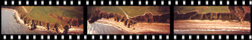
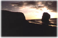
Photo's of the coast